
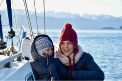
We’ve entered the Strait of Magellan! The entire sky, the summits of the snow-covered mountains and the waters of the Magdalena Channel are flooded with sunlight. Straight ahead lies a new milestone on our great journey. We are entering the legendary Strait of Magellan! The sails have caught the fresh breeze, and the stem is cutting through the waters of two great oceans at once. Five hundred years ago, less 15 months, the Trinidad—the flagship of Ferdinand Magellan’s fleet—passed through here.
15 August, Thursday. A glacial fjord and a granite embankment in the shower.
Today is a short passage: 6 miles to the anchorage, literally just around the corner into the large, beautiful Seno Chico fjord. The forest hides from the wind in the clefts of the steep slopes. Fresh rockfalls are marked by scree and dead trees. Two miles farther on, there is a narrow offshoot, the Alacaluf Fjord, with a glacier. We want to take a look before stopping for the night. The turn towards the glacier is marked by floating ice that has drifted out into the main fjord as well. All the gaiety of the sunlit patches on the steep slopes is swallowed by the misty grey. The low winter sun instantly disappears behind the ridge. At the vaults of the high walls, there is only a narrow corridor of hazy sky. A graceful, many-streamed waterfall pours down from the very top of the ridge, its narrow streams parting, then coming together again.
For months on end, the sun does not reach the bottom of Fjordo Alacaluf, leaving it to slumber among the ice. Birds sit on the floes, looking like penguins from a distance. Upright, black-backed, white-bellied—everything just as it should be for penguins. Yet these pseudo-penguins take off after a running start across the water. I study one through the binoculars. Its back is blue-black, its wings simply black, and there is a yellow outline around its beak. I’ll have to read up on what kind of bird it is. There are no penguins to be seen in winter; they say they head out into the ocean for six months.
Lady Mary proceeds at dead slow, nudging floes and mini-icebergs. The ice slurry grows thicker and thicker, while only the very edge of the glacier is visible. Most of it seems to be around the headland. Nastya perks up at the change of scenery, cheerfully comparing the rather gloomy fjord to Antarctica. And it really does look like it, if you cover the sparse bare bushes completely in snow and set a dozen blue icebergs afloat. When someone suggests dropping anchor at the entrance to the glacial fjord, I refuse. I much prefer being anchored among trees. Especially since the anchorage we passed an hour earlier was marked by a rainbow. The coloured arch planted its feet in the water precisely to the left and right of the entrance to the bay. I think it’s a sign: that’s where we need to go.
The forest hides in fissures and hollows. Cascades of icicles. Streams of tears flow down the walls. Weeping waterfalls, like jets from a shower, are stretched out horizontally. We left the captain in charge and rowed off to survey the perimeter of the bay. We went within two metres of the shore, examining the details. We found a hidden little inlet where, at high tide, our yacht might just squeeze through with difficulty, her mast knocking aside the splayed branches. You could hide an entire tribe of Indigenous canoes there from European conquerors.
On the bottom are red crabs, grey starfish with long arms and lots of large mussels, which, to be on the safe side, we no longer collect. The shore beside the yacht resembles a granite embankment sloping into the sea at an obtuse angle. To reach a tree and tie on, you have to put in some effort. In the morning we leave at low tide so that it coincides with the fair current. Nastya takes the long way round to untie the lines from the tree, because there is simply no climbing straight up that sloping granite embankment without a single handhold.
16 August, Friday. A quiet harbour and a stuck anchor.
We entered the bay of Puerto Hope, scattering wild ducks—black ones, black-and-white ones, and grey ones with red bills. We never saw any like these in the far south, so it must be warmer here. Some English navigator named this forest lake Port Hope. Perhaps someone’s ship found refuge here during a savage storm.
The trunks of the beeches curve up from the very water. The ducks choose different tactics for avoiding an encounter. Some dive in all directions, looking like a panicked rout. Several times, only a beak appears above the water: the bird takes a breath and then scuttles away underwater again. Several others take wing, circle along the gently sloping shore and alight on the opposite side.
There is more evergreen broadleaf forest now. On a clear morning, the curves of the hills and carved foliage ring with the half-tones of shadows and sunlight. What a joy it is to live beneath the sun! As we raise the anchor, the captain whistles everyone on deck. Get in the dinghy! With a knife! Er... Um... ? The broad expanse of the bay allowed us to spend the night riding to the anchor alone, without shore lines. As a result, all the flora on the bottom wound itself around the chain like thread around a bobbin, gripping it in a death hold. The windlass cannot lift the anchor out of the water.
The captain jerked the yacht by opening the throttle. We broke free of the bottom, but the anchor was still entangled in a weight the windlass could not lift. Judging by the effort required, we had at least a hundred kilos of seaweed down there. For half an hour I hacked leaves and springy stems off the chain and anchor. Mud and leaves flew into the dinghy and onto my railway-worker outfit. We dunked the anchor and hauled it up again. Then I washed the dinghy, sliced slabs of clay off the anchor and withdrew to the stern for water treatments involving a bucket of rainwater.
17 August. The Strait of Magellan!
We had barely come around the corner into the sunlit Magdalena Channel when something in my solar plexus began whispering: everything is different today. The three-week fjord leg is over, and it ended just in time. The wilderness, nooks and crannies, snow and dense, primeval beauty have been left astern together with the clouds. We wonder whether an anticyclone has arrived, or whether the clouds and fog are still hanging over the Pacific side of Tierra del Fuego, cut off from the mainland by a broad strait with a bend in the middle.
The sky, the snow-covered mountains and the waters of the Magdalena Channel are flooded with sunlight. Straight ahead lies a new milestone on our great journey. We are entering the legendary Strait of Magellan!
The sails have caught the fresh breeze, and the stem is cutting through the waters of two great oceans at once. Five hundred years ago, less 15 months, the Trinidad—the flagship of Ferdinand Magellan’s fleet—passed through here. They covered the strait’s 550 km in 34 days, sometimes running into dead ends—one of them was the bay named Useless—and sometimes being caught in storms. On top of that came mutinies, betrayals by officers and the loss of ships. The Strait of Magellan is the most difficult area in the world for navigation. The caravels sailed against strong winds, through unknown waters with shoals and submerged rocks, with 12-metre tides and powerful currents dangerous even to large modern ships. Without sailing directions or navigational instruments, radios or heaters, losing up to 90 percent of their crews. But they went on, driven by the great idea of doing the impossible. Well, according to the version presented to their royal sponsors, to find a western route to the Spice Islands.
We enter the legendary strait exactly at its midpoint, from the south, at the bend between its broad eastern section and its narrowing western part. Sensing their freedom, the sails catch the wind and carry us into the vast bay of Bahía San Nicolás, where the ships of the great Magellan may also have taken shelter for the night 499 years ago. The young sailor and I land on the southern shore of the South American continent and find a fisherman’s shelter, fox tracks, red algae and an unidentified skull. The city of Punta Arenas is about 50 miles away.
You can see us in the Strait of Magellan and follow the expedition in real time on our website under the Route tab, where our Iridium track is recorded. Every 2 hours, the radio beacon sends a signal to the satellite; the points on the map are combined with the weather forecast, provide a basis for calculating speed, and are turned into a nice, informative graphic. The same map, with the track and details, is available at bit.ly/iridium360.
Thank you to everyone who has been wondering where the Support the Expedition link disappeared to from our page. Before we entered the fjords, our website developed problems that have still not been fully resolved. As a temporary measure, Andrey removed most of the links leading to third-party resources, including Paypal.me/TravelyFamily. You can still use that link to contribute to the ship’s kitty and become part of our far-from-easy expedition. Friends, thank you for being there for us! We’ll be in touch from the Strait of Magellan!